The Wilson Trail 7
Shing Mun Reservoir via jogging trail, Shing Mun Forest Track and
Lead Mine Pass to Yuen Tun Ha. Distance 10.2km can be easily done
in 2« hours. Degree of difficulty: 1.
Question: what is the fastest way to get from Kwai Chung or Tsuen
Wan to Taipo Market while not using public transport. Answer:
Walk all of the Wilson Trail stage 7. This section is by far the
easiest of the entire trail, but thoroughly enjoyable. Although
I certainly do not want to encourage you to break the law by
riding a bicycle along the jogging trail that contours the
eastern part of Jubilee or Shing Mun Reservoir, it would be a
feasible thing to do.
One of Hong Kong's oldest reservoirs
The trail is that flat! Therefore it is
ideal even for a family with small children. But if you really
want to cycle, it is definitely possible; I have seen people do
it. As long as you manage to get up Wo Yi Hop Road and Shing Mun
Road in Tsuen Wan, the rest is almost a piece of cake: there is
a concrete secondary road that runs parallel (about 50m higher
in elevation) with the jogging trail incorporated in the Wilson
Trail and joins it at the northern tip of Jubilee Reservoir.
If you do not join stage 7 from the previous walk, or from Tai
Wo KCR near Shatin (see Excursion 2 of 'The MacLehose Trail and
Its Surroundings'), then the easiest way to join Stage 7 is to
take the MTR to Tsuen Wan and find PLB # 82 to Pineapple Dam.
These minibuses leaves every few minutes on Saturday and Sunday,
but you need a bit more patience during the week. From there it
is a 10 mins walk to the main dam along the reservoir.
Alternatively, if you want to get completely rested to the start
of stage 7, you may take a taxi from Kwai Hing MTR. It will cost
$32 via Wo Yi Hop Road to the main dam and if you alight at
Pineapple Dam a mere $24. This is a good alternative if there
are 3-4 of you, and certainly during a weekday. The start of
stage 7 is right across the main dam. At the exact spot where you
would turn right to join the MacLehose Trail up Needle Hill, the
Wilson Trail continues immediately on the left along the water
front. The concrete secondary road referred to above is found up
the steps straight ahead.
There is an information board and detailed map on the corner. The
old jogging trail map indicates that you may do the forst part
of this section being 5km in about 40 mins. The Wilson Trail
information map wisely does not advise you to speed up. It is as
good a jogging path you will find in Hong Kong. It is broad
enough, sheltered most of the way against the piercing rays of
the sun in summer and gives regularly lovely views over the
reservoir. Tai Mo Shan (Hong Kong highest mountain) is clearly
visible most of the way and often straight ahead since this path
twists and turns and follows the embankment almost entirely.
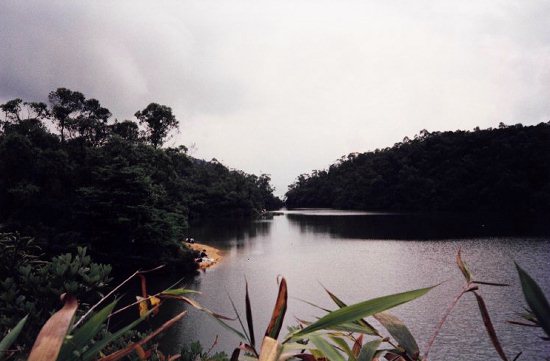
On a weekday the nature is at its most perfect; towards the end
of it (at the 4,000 meter stage), the reservoir looks like a
secluded lake you would encounter somewhere in Finland or Sweden.
You expect to see a sauna at any moment with curling smoke of
birch logs from a chimney announcing that it is time for a bath.
When the trail turns north again, it suddenly rises and joins the
secondary road. Turn left; the road dips almost at once and soon
comes to a large lawn with an enormous tree and a small stone
formation that resembles a hunebed. An ideal spot for a picnic.
The road then slowly rises again, there is a fork with an
information board, map and a small shelter. If you continue left
you would end up near Pineapple Dam. Turn right to Tai Po. Most
of the rest of the following journey to Leadmine Pass is tree
covered, and very enjoyable even in the heart of summer.
There is another fork at the halfway stage. You should turn left
here for the shortest journey to Lead Mine Pass. Turning right
will also take you to Lead Mine Pass but add another km to your
journey. It is well worth the small extra effort (the road is a
bit steeper) if you have time to spare and certainly if you are
interested in trees. The Tso Shan Arboretum is an open air tree
museum, and though not as extensive as the Kadoorie Farm, it will
give you a magnificent insight in most Hong Kong tree species.
Upon reaching Leadmine Pass, a right turn will take you to Grassy
Hill and Tai Po Kau Nature Reseve, one of Hong Kong's finest
walking areas hugely popular with residents in Tai Po and Shatin
alike. But it is a diversion that would take us too far. A left
turn up the hill takes you along stage 8 of the MacLehose Trail
towards Tai Mo Shan. You are crossing this trail here for the
last time. Our path lies straight ahead and then gently leads
down to the valley in which Tai Po has nestled. It has grown from
a village of just 30,000 souls in the early 70s to about 200,000
people at the latest census. The view over Tai Po and Tai Wo,
Hong Lok Yuen (the luxury suburb for expatriates and well-off
local executives) on the left and Tolo Harbour on the right is
very impressive. The Pat Sin Leng range beckons with Cloudy Hill
in the middle. This is the final and most rugged section of the
Wilson Trail. If you do not feel up to it, wait for tomorrow.
You will have to walk carefully part of the way down since some
of the stones are rather uneven until we reach Yuen Tun Ha. If
it has been raining, it is entirely likely that you will stumble
or slip once or more. Even if you walk slowly, it will take you
not longer than 30 mins to reach this former hamlet. There are
no houses anymore at Yuen Tun Ha; the name now just refers to a
catchment area for the waterworks department.
When the trail turns almost 180ø, there is a path that leads to
a lovely Buddhist temple and monastery at Ta Tit Yan (0.6km
according to the sign and a slight incline almost in the
direction you came from). Turn twice left to arrive on the
secondary road. Stage 7 of the Wilson Trail officially ends here.
If you want to end your walk here, walk another km to Sam Uk Ha,
a cluster of farm and squatter houses on the left. Minibus 23K
stops here and turns around. All PLB and KMB buses in the Kowloon
and New Territories with a 'K' indicate that they will connect
you with a KCR station; it is that easy). This PLB will take you
to Tai Po Market KCR for a direct connection to the urban area.