Excursion 4 (MacLehose Trail)
Walk from Tsing Lung Tau and Sham Tseng via Tai Lam Chung
Country Park is about 7km. It can be walked comfortably within
four hours. Degree of difficulty is a 2 and 3 when it has been
raining. Allow for a full day to really enjoy it, if you want
to have a leisurely dinner afterwards in Sham Tseng.
Even the most enthusiastic hikers of my acquaintance tend to
be ignorant of the fact that there is a lot of coyntryside
still to be discovered between the traditional MacLehose Trail
and the shoreline that runs between Tsuen Wan and Tuen Mun. I
had made a few forays over the years, but was alerted only
last year about this hike by my friend Alan Crawley, long-time
resident of Hong Kong and an indomitable hiker himself.
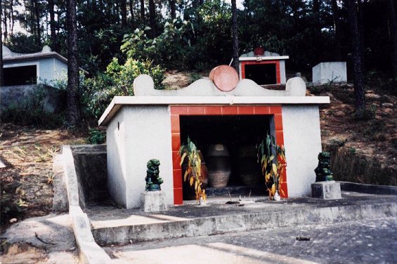
Second stage of the traditional burial process
To get to the starting point of this excursion, take the MTR
to Tsuen Wan (final stop) and walk to the western exit. The
busstation is located below Nan Fung Centre and can be seen
just across the road. However, to get the right public
transport, you need to walk over the pedestrian flyover one
road further south. Castle Peak Road continues here west.
You should position yourself between the Hong Kong Bank branch
here and the Telecom CSL shop (100m down the road) to catch
KMB bus 52X (HK$4.30 to Tuen Mun Town Centre) or minibus 96 or
96M to Tsing Lung Tau. The latter is actually your best bet,
as it runs every five mins and stops on the exact access road
you need to take for this hike into the hills.
Once you pass Sham Tseng (your final destination for the hike)
which is the home of Hong Kong's premier beer San Miguel and
the countless goose restaurants, it is time to make sure you
get off at the right point (if you travel on 52X). There are a
number of newly built high-rises by Hong Kong's largest
developer Sun Hung Kai on this stretch of Castle Peak Road.
Tsing Lung Tau is just around the corner of the last one
called Sea Crest Villa. This new town has an unimpeded view of
the new bridge between Tsing Yi, Ma Wan and Lantao Islands
(see photo of the beach). There is a lovely Taoist temple just
200m from Lung Yue Road where PLB 96 turns right.
There are several soft drink stores on the corner that allow
you to provision yourself. The road begins a steady ascent and
passes under the Tuen Mun highway. One of the most common
mistakes made by hikers (including myself in the past) who
want to travel along the coast is to get on any bus that
leaves from Tsuen Wan west. Most of them take the highway, and
you cannot get off until you are in Tuen Mun. This turns out
to be a very nice practical joke if you get stuck in a traffic
jam. By the time you are in Tuen Mun, there may not be enough
time to do your planned walk!
Time for an orange-snack
It is almost exactly 1km from the beach to the start of the
country park where there is a fork in the secondary road. The
road stops rising at this point if you take the road to the
Country Park Management Centre (straight ahead). You will find
a map of the countryside on the left. We are taking the road
to the left towards Yuen Tun. There is a barrier across the
road normally manned during day-light hours by a warden. This
road swivels left and continues to climb steadily. The bridge
to Lantao and the new airport can be seen even more clearly
once you round the corner. The split in the road to Yuen Tun
(Civil Aid Services Camp) occurs after another 1,200m. Please
continue to the direction of Tsing Fai Tong. You will hear a
brook running on the right.
After about 150m, i.e. once you round the next corner, you
will find a bridge over a shallow pool of water. Just across
it on the left you will see a path that leads uphill through
the bushes. If you have no intention of going on this
excursion but just want to join the 10th section of the
MacLehose Trail, please continue straight ahead along the
hardened secondary road. The Country Park Management Centre on
the most north-eastern point of Tai Lam Chung Reservoir will
be reached within an hour from this point by following (1) on
the map in the back of this book.
The main adventure of our excursion (trail 2) actually starts
here. The path is surprisingly good through the bushes, the
main reason being that there are a lot of graves on the slope,
many of them recently dug and well-tended (see photo). Follow
the red pieces of cloths when in doubt. They have been hung
there by 'orienteering' squads or the local chapter of Hash
House Harriers (internationally redoubted explorers of the
countryside). Once you reach the highest point, there are
three paths you can take. Opt for the middle one that will
give you the easiest access through the forest to the other
side of the hill.
Forest Trail near stage 9